The Morning the Map Changed
If you drive State Highway 87 through Galveston County today, the landscape plays tricks on you. The sightlines from the pavement to the Gulf of Mexico are wide open. For miles through communities like Crystal Beach and Gilchrist, you can roll down the window and smell the salt spray without a single structure blocking your view.
It looks peaceful. It is actually a scar.
Finding physical Bolivar Peninsula Hurricane Ike wreckage today requires knowing exactly what you are looking at. You won't find many twisted steel beams or splintered timber anymore. The ocean took care of that. Instead, the wreckage exists as empty space. It is the missing driveways ending in grass. It is the concrete pylons leading to thin air.
🌊 The Anatomy of a Wipeout
When Hurricane Ike made landfall at 2:10 a.m. on September 13, 2008, it carried sustained winds of 110 mph. That technicality classified it as a Category 2 storm on the Saffir-Simpson scale, a label that lulled too many residents into staying behind. The real danger of Ike wasn't the wind speed. It was the sheer size of the storm, pushing a dome of water 14 to 20 feet high directly at the upper Texas coast.
Bolivar Peninsula took a direct, catastrophic hit. The geography of the peninsula makes it deeply vulnerable—a low-lying barrier of sand separating the Gulf of Mexico from Galveston Bay. The community of Gilchrist sits at the peninsula's narrowest choke point.
The town faced a brutal, two-front water assault. First came the head-on storm surge from the Gulf, battering the coastline with 20-foot waves and sweeping houses off their foundations. But the killing blow came from the opposite direction.
As Ike's massive eye moved inland and north, the counter-clockwise wind rotation shifted. The storm began forcefully draining the swollen waters of Galveston Bay. That water had nowhere to go but back out to the Gulf of Mexico—directly over the Bolivar Peninsula.
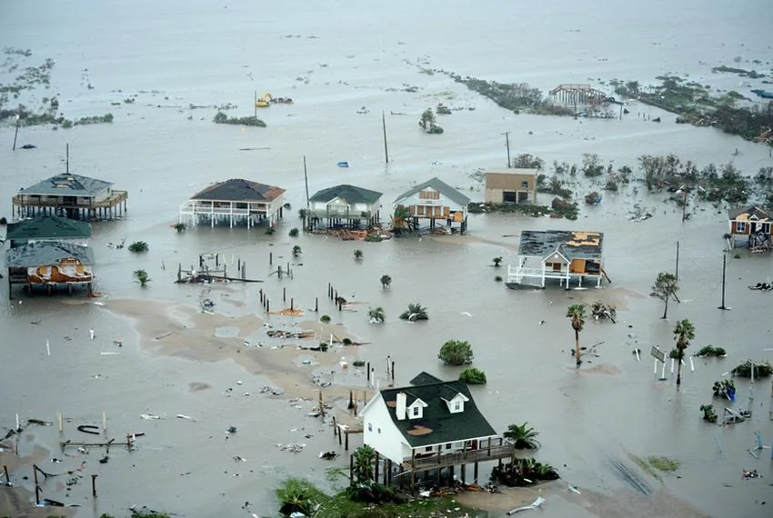
This reverse surge dragged the town of Gilchrist out to sea. It didn't just knock houses down; it erased them. Of the roughly 1,000 structures in Gilchrist before the storm, exactly five survived. Search and rescue teams arriving in the aftermath faced a surreal problem. They couldn't comb through the debris for survivors because the debris was completely gone.
Highway 87, the main artery connecting Port Bolivar to High Island, was peeled off the earth. Entire sections of asphalt fractured and washed into the marshlands.
The Last House Standing
In the days following the storm, aerial photographs revealed an image that defined the disaster. Amidst a scoured, apocalyptic wasteland of mud and missing neighborhoods, a single yellow home stood completely intact on the Gulf side of Highway 87.
It belonged to Warren and Pam Adams. They had lost a previous home on the exact same lot to Hurricane Rita in 2005. When they rebuilt, they demanded a structure capable of handling the Gulf's worst temper tantrums. Contractors elevated the yellow house 14 feet in the air on thick wooden columns, deliberately exceeding standard building codes.
The surge completely gutted the interior, ruining the furniture and turning a grandfather clock into scrap. But the framing held. The roof stayed attached. For 14 miles along the coast, it was the only house left.

A Ghost Town Rebuilt
Bolivar has bounced back, but the demographics and the architecture have permanently shifted. The small, ground-level fishing shacks and cinderblock bait camps of the 20th century are gone. The houses replacing them are massive, multi-story rentals perched on towering wooden stilts, engineered to let the next inevitable surge pass underneath.
If you know where to look in the marshes behind the peninsula, you can still find the occasional waterlogged piling or rusted engine block. But the true wreckage of Ike is the memory of the communities that used to line that highway, washed into the bay before the sun came up.
Have you driven down Highway 87 since the rebuild? What changes stand out to you the most?
<!-- ebt-meta:{"cities": ["galveston"]} -->




No comments yet