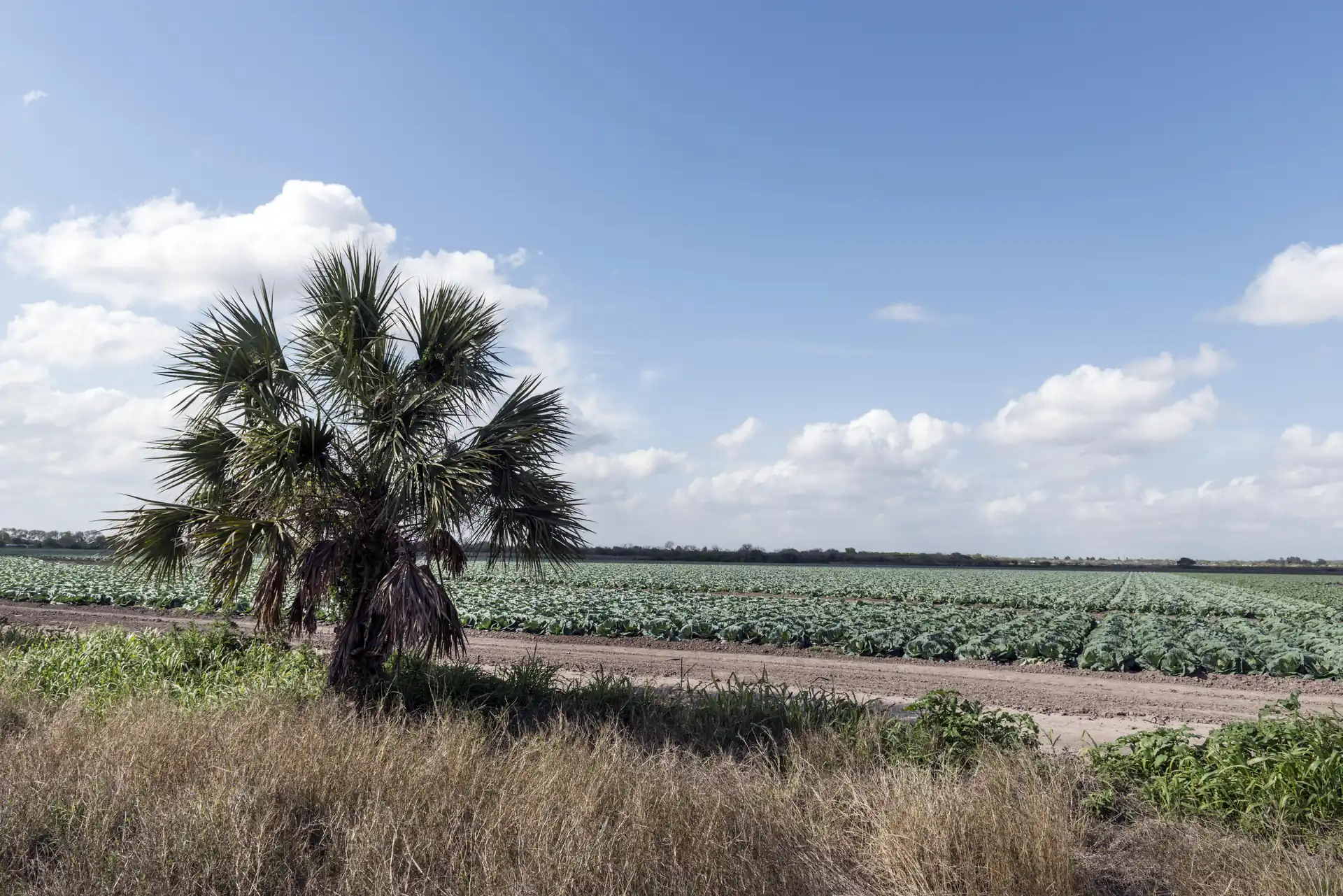
Stand at the edge of almost any farm field in the Lower Rio Grande Valley and the first thing you notice isn't the crops. It's how flat everything is. The sky takes up half your vision, the horizon is a ruled line, and whatever grows in between — sugarcane, sorghum, cabbage, onions — seems almost incidental against that enormous South Texas emptiness.
That's what makes this photograph from the Library of Congress so quietly striking. A single palm tree at the edge of a produce field in Cameron County. The Rio Grande somewhere close behind it. And everything else — the geometry of cultivated rows, the deep color of irrigated soil, the particular quality of South Texas winter light — filling in the rest.
It's not a dramatic image. But it doesn't need to be.
Cameron County and the Farm That Fed America's Winter Table
Cameron County sits at the absolute southern tip of Texas, bracketed by the Gulf of Mexico to the east and the Rio Grande to the south and west. Brownsville is the county seat. Matamoros, Tamaulipas sits just across the river — close enough that you can hear it.
What people outside the Valley often don't understand is just how productive this land is. The Rio Grande Valley isn't really a valley at all in the geological sense; it's a broad alluvial delta, built up over thousands of years by sediment deposited by the Rio Grande as it braids toward the Gulf. That sediment is extraordinarily fertile. Add a subtropical climate with roughly 26 inches of annual rainfall and access to irrigation water drawn from the river itself, and you have conditions that allow farmers to grow crops year-round — or close enough to it.
By the early twentieth century, that productivity had attracted serious agricultural investment. The St. Louis, Brownsville and Mexico Railway reached Brownsville in 1904, and irrigation canals followed. Land companies — many of them operating out of St. Louis and Kansas City — began marketing Valley farmland aggressively to Midwestern buyers, promising year-round growing seasons and proximity to northern markets via rail. By 1920, Cameron County alone had more than 100,000 acres under cultivation.
That number is harder to process than it sounds when you're standing in a field that stretches to the horizon in every direction.
What "Produce" Actually Meant in the Valley
The LOC metadata lists this photograph under "produce" — a broad term that in Cameron County could mean any number of things depending on the season and the decade. The Valley built its commercial agricultural identity around a rotating calendar of crops.
Winter vegetables were the foundation. Onions, cabbage, carrots, and leafy greens shipped north during months when northern farms were frozen solid. By the mid-twentieth century, Cameron and Hidalgo Counties were supplying a significant share of the nation's winter onion crop. Texas A&M's agricultural extension records from the postwar period show the Valley producing upwards of 60 million pounds of onions in peak years.
Citrus came later — grapefruit especially. The Ruby Red grapefruit, developed through a mutation found in a Hidalgo County orchard in 1929, became one of the most commercially significant agricultural discoveries in Texas history. Cameron County growers adopted it quickly.
And then there was sugarcane, which had been grown in the Valley since the nineteenth century and experienced periodic booms tied to national sugar prices and trade policy.
This photograph, captured digitally in 2014, doesn't specify the crop. The rows are there, the color is lush, and the season — based on the quality of the light and vegetation — suggests active growth. But identifying the exact crop from description alone isn't something I'll speculate on.
The Palm Tree at the Edge of Everything
Here's the thing about that palm tree.
It's not an accident. Farmers in the Lower Rio Grande Valley have used trees — palms, ebony, retama, huisache — as windbreaks and property markers for generations. A lone palm at the edge of a field almost certainly marks a fence line, a road edge, or a property boundary. Mexican fan palms (Washingtonia robusta) and Sabal palms (Sabal mexicana) — the latter being Texas's only native palm species — both appear commonly throughout Cameron County in exactly this kind of roadside or boundary planting.
The Sabal palm, for what it's worth, is remarkable. It once formed dense forests along the Rio Grande delta. By the twentieth century, most of those forests had been cleared for agriculture. Today, the Sabal Palm Sanctuary near Brownsville protects one of the last remnant groves in the United States — about 557 acres of habitat that gives you a real sense of what this entire landscape looked like before the plows arrived.
A single palm at a field's edge is, depending on how you want to read it, either a survivor or a remnant. Either way, it earns the composition.
The Rio Grande as Agricultural Lifeline — and Legal Boundary
The presence of the Rio Grande in this photograph's metadata isn't just geographical context. It's everything. The river is why this field exists.
Water rights in the Lower Rio Grande Valley are among the most legally complex in Texas — and Texas water law is already notoriously complicated. Unlike the western doctrine of prior appropriation that governs most arid-state water rights, Texas uses a hybrid system, and Rio Grande water rights are further complicated by a 1944 international treaty between the United States and Mexico that allocates river water between the two countries.
In simple terms: Valley farmers have been fighting over, negotiating for, and sometimes losing access to Rio Grande water for over a century. Drought years are not academic concerns here. When the river runs low — as it has in the twenty-first century with increasing frequency — fields like the one in this photograph don't get planted.
That context sits underneath any photograph of a productive Valley farm field. The lush green rows represent an enormous amount of work, investment, legal history, and water that had to be fought for.
The 2014 Frame
This image was captured in 2014, which places it in a specific agricultural and environmental moment. The early 2010s brought serious drought conditions to much of Texas, including South Texas. Cameron County farmers were navigating depleted reservoir levels and ongoing disputes over Rio Grande water allocations. And yet — the field in this photograph is clearly producing. Someone kept the water flowing.
That's worth sitting with for a second.
The Valley's farmers have survived floods, freezes, droughts, trade disruptions, and the steady pressure of urban development converting farmland to subdivisions from Brownsville to McAllen. The field in this photograph is not a relic. It's evidence of an agricultural economy that's still working — still planting, still irrigating, still shipping produce north while the rest of the country is dealing with January.
If your family farmed in Cameron County or anywhere else in the Valley, we'd love to hear what crops your people grew and what years were the hardest ones. Drop a comment below — that kind of firsthand knowledge doesn't show up in any archive.
No comments yet