The Guadalupe River rose twenty-six feet in less than an hour on the morning of July 4, 2025. Most of the people it killed never heard a siren, because there wasn't one. Texas has been having this argument with water since before it was a state, and the argument keeps landing in the same place: the rain comes faster than the warning does.
September 8, 1900: The Night Galveston Disappeared
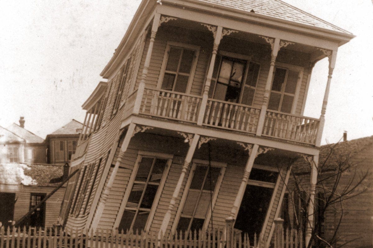
Before sunrise on September 8, 1900, Galveston was the largest, wealthiest city in Texas — a deepwater port crowded with cotton brokers, a thriving downtown, a population pushing 38,000. By the next morning, a Category 4 hurricane had killed somewhere between 6,000 and 12,000 people on the island, with the most-cited figure standing at roughly 8,000. It remains the deadliest natural disaster in United States history. A storm surge of 15 to 16 feet rolled over an island that sat barely 8 feet above sea level at its highest natural point, and the water did what water does to a place with nowhere to go — it took out close to 3,600 homes and left the survivors standing in wreckage that stretched the width of the island.
What happened next is the part of the story Texans tend to skip past, and it's the more interesting half. A three-man board of engineers — Henry Martyn Robert, Alfred Noble, and H.C. Ripley — spent over a year studying the problem and came back in January 1902 with an answer nobody had attempted at that scale before: build a seawall, then lift the city itself above the water that had just drowned it. Construction crews dredged sand from the harbor entrance through a two-and-a-half-mile canal, floated it under entire buildings on temporary supports, and raised roughly 500 city blocks one quarter-mile section at a time — lifting houses, churches, streetcar tracks, and water and sewer lines together as each section came up. By the time the work wrapped in 1911, the Gulf-facing edge of Galveston sat as much as 17 feet higher than it had on the morning of the storm. The seawall itself, completed in its first 3.3-mile stretch on July 29, 1904, still stands. It held through the hurricanes of 1909 and 1915, and it's still doing its job 120 years later.
Galveston's answer to flooding was permanent and physical: raise the ground. Most of the rest of Texas would spend the next century discovering that not every flood problem can be solved by elevation alone — because Houston's problem, when it came, wasn't the Gulf pushing in. It was the sky falling straight down and the bayous having nowhere to put it.
Houston Learns What "Stalling" Means
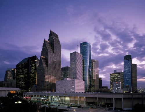
Tropical Storm Allison never reached hurricane strength. It made landfall near Freeport on June 5, 2001, weakened almost immediately to a tropical depression — and then did the one thing meteorologists fear more than wind speed: it stopped moving. For four days, Allison's remnants sat over southeast Texas and wrung themselves out, dropping rainfall totals that topped 38 to 40 inches in parts of northeast Harris County. The National Weather Service's Houston/Galveston office later put it plainly: you don't need a hurricane to produce a catastrophe, you just need the rain to refuse to leave.
Houston's bayous, built for a drier average year, simply could not move that much water. Downtown flooded. The Texas Medical Center — one of the largest hospital complexes on Earth — took on water in its basements, destroying research and knocking out emergency services in the middle of the crisis. Roughly 23 Texans died, most in flash flooding, out of a national toll that reached into the low 40s. The storm caused billions in damage, with NOAA's CPI-adjusted figure later put at $15.1 billion, and it left more than 14,000 homes destroyed or majorly damaged.
Allison became the reason Harris County Flood Control District exists in its modern, well-funded form. The district has since spent well over a billion dollars widening bayous, building detention basins, and rewriting how Houston thinks about a hundred-year flood. It was, by every account, a serious response. It was not, as the next decade and a half would prove, enough.
Harvey: The Storm That Broke the Rain Gauge
Hurricane Harvey made landfall as a Category 4 storm near Rockport on the night of August 25, 2017 — the first Category 4 to hit the U.S. mainland since 2004. The wind damage near the coast was real, but Harvey's signature wasn't wind. Like Allison sixteen years earlier, it stalled, this time parked over southeast Texas for days with nowhere to go and an entire Gulf of Mexico to draw moisture from.
The numbers that came out the other side are still difficult to process. Cedar Bayou, on Houston's east side, recorded 51.88 inches of rain — a new North American tropical-cyclone rainfall record. NOAA's hydrologists calculated that much of metro Houston experienced a rainfall event with a return period exceeding 1,000 years; some analyses put parts of it past 9,000. More than 300,000 structures flooded. Up to 500,000 vehicles were destroyed. The National Hurricane Center's official tropical cyclone report counted 68 direct deaths, every one of them in Texas, 36 of them in Harris County alone — the most direct deaths from a hurricane in the state in 98 years. None of those deaths came from storm surge. All but three came from freshwater flooding, the same mechanism that drowned Allison's victims, on a scale Allison never approached.
Harvey cost an estimated $125 billion, the second-costliest hurricane in U.S. history after Katrina. It also confirmed something Houston's engineers had started to suspect after Allison: the city's flood infrastructure had been built for a climate that no longer matched the one delivering the rain.
Flash Flood Alley
Two hundred miles west of Houston's bayous, Hill Country has its own name for the same problem: Flash Flood Alley. The Balcones Escarpment — the geological fault line where the Edwards Plateau drops down toward the coastal plains — creates a landscape of thin soil over limestone, steep-sided river valleys, and almost no capacity to absorb a hard rain. When a storm parks over the Hill Country the way Allison and Harvey parked over Houston, the water doesn't soak in. It runs straight downhill into rivers like the Guadalupe, the Blanco, and the San Marcos, and it can turn a calm river into a wall of water within the time it takes to wake up.
The region had already proven this. In May 2015, the Blanco River near Wimberley rose to within reach of 30 feet in a matter of hours, killing 13 people. Kerr County officials took notice — Tom Moser, a county commissioner at the time, proposed building a Wimberley-style warning system for the Guadalupe. It was judged too expensive and never built. The county applied for federal disaster-mitigation funding for a flood warning system in 2017, was denied, applied again after Harvey in 2018, and was denied again. A 2017 commissioners' meeting on the subject of outdoor sirens is on record with one commissioner objecting to "these damn sirens going off in the middle of the night." In the years since, Texas operated a $1.4 billion state fund specifically to help local governments pay for flood mitigation; ProPublica and the Texas Tribune later found that at least 90 local governments, including the river authority covering Kerr County, turned down money from it.
July 4, 2025
The Guadalupe River rose more than 20 feet in roughly 45 to 95 minutes in the predawn hours of July 4, 2025, after a slow-moving storm system dumped what officials described as more than an entire summer's worth of rain on the watershed in a few hours. The National Weather Service had issued a flash flood watch the previous afternoon and escalated to flash flood warnings and at least one flash flood emergency overnight — by some counts, 22 separate NWS warnings went out before the river crested. Kerr County had no outdoor warning sirens and had not activated the CodeRED cellphone alert system. Most people along the river were asleep, in an area with notoriously weak cell coverage, when the water arrived.
Camp Mystic, a girls' summer camp on the river in the community of Hunt, lost 27 campers and counselors. As recovery efforts continued through July, officials raised the confirmed statewide death toll in stages — past 100, then past 120, settling in mid-July reporting at roughly 134 to 136 confirmed dead across the affected counties, with Kerr County accounting for the large majority, including dozens of children. It stands among the deadliest inland flooding events in modern Texas history.
The contrast with the town of Comfort, twenty-some miles downriver in Kendall County, did not go unnoticed. Comfort had recently installed two new sirens — one at the volunteer fire department, one moved to a low-lying area along Cypress Creek — and used the new system for the first time outside of a test that same night. "People knew that if they heard the siren, they gotta get out," the department's assistant chief told reporters afterward. Comfort had no flood deaths that night.
What Changed, and What Hasn't Yet
Governor Greg Abbott called a special legislative session for July 21, 2025, with flood warning systems and flood emergency communications named explicitly on the agenda. Out of it came Senate Bill 3, signed September 5, 2025, which directs the Texas Water Development Board to study the 30 counties under the July disaster declaration and identify where outdoor sirens are warranted. Senate Bill 5, signed September 18, appropriated $50 million from the state's economic stabilization fund toward local flood-preparedness grants in those same counties. House Bill 1 and a companion Senate bill, also signed that week, require youth camps to file emergency plans with the state, train staff on flood response, install warning systems, and — going forward — keep cabins out of mapped floodplains.
As of this past December, reporting out of Kerr County found that despite the new laws, no sirens had actually been installed yet, with officials pointing to the gap between a state mandate and the funding required to execute it. The Upper Guadalupe River Authority's general manager said a complete warning system, built out fully, could still take years. It is the same sentence, in different words, that Kerr County officials have been saying since 2017.
The Shape of the Next One
Texas doesn't get one kind of flood. It gets storm surge on a barrier island that sits at sea level, slow-stalling tropical systems that drown an oil-and-shipping metropolis from above, and flash floods that turn a Hill Country creek lethal before a phone alert can buzz. Galveston answered its flood with concrete and elevation, a fix so durable it's still working over a century later. Houston answered Allison with wider bayous and answered Harvey by realizing wider bayous weren't the whole answer. Kerr County is still, as of this writing, in the gap between the disaster and the fix — a $1 million siren system that's been "deferred" since 2018, now a state mandate without a finished installation.
The geography isn't going anywhere. The Gulf will keep feeding moisture into stalled storms, the Balcones Escarpment will keep funneling Hill Country rain into narrow river valleys, and low-lying coastal cities will keep building in places water already knows how to reach. What's actually changed, storm to storm, is whether the people downstream had a warning. Galveston's seawall is concrete you can still walk on. Comfort's sirens are a budget line item that got approved. The next flood is not a question of if — Texas has never gone a generation without one. The open question, the one the state is still answering in real time, is how many minutes of warning the people in its path will get.
What's your family's flood story — Galveston, Allison, Harvey, or somewhere closer to home? Drop it in the comments.

No comments yet