The Sabine River doesn't look like much from the highway. Dark water, cypress knees pushing up through the shallows, the kind of dense East Texas bottomland that swallows sound. But for a brief, strange window in history, that river was an international border — and the map that formally recorded where it ran took years to produce, survived bureaucratic delay, and ended up in the hands of Congress just in time to matter.
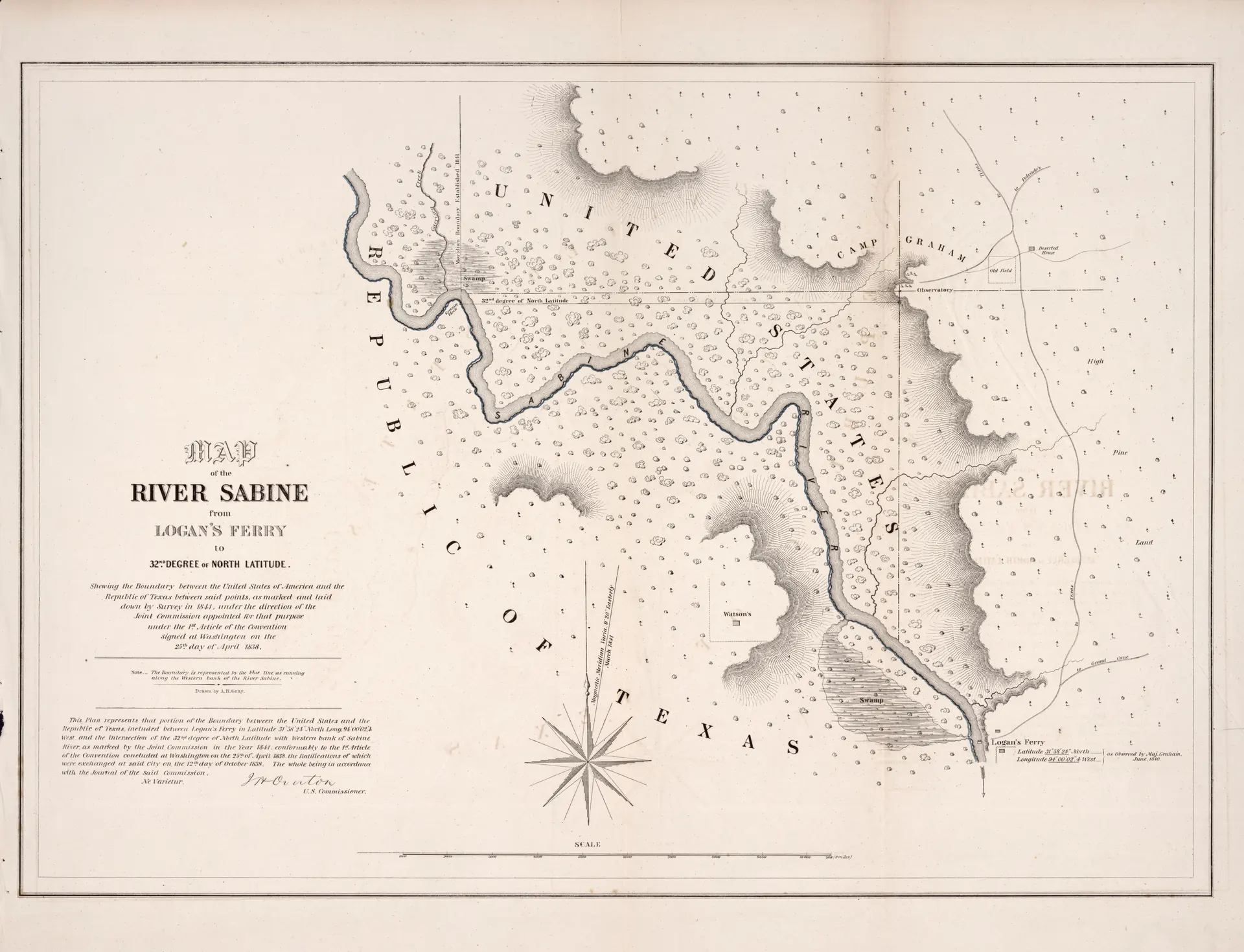
The map in question was created by Andrew Belcher Gray in 1842. Its full title tells you exactly what it is: Map of the river Sabine from Logan's Ferry to the 32nd degree of north latitude, shewing the boundary between the United States of America and the Republic of Texas between said points, as marked. No poetry in that title. Just precision. That was the point.
Two Nations, One River, One Very Delayed Map
To understand why this document existed, you have to remember what Texas was in 1842.
Not a state. A republic. Six years had passed since the declaration of independence at Washington-on-the-Brazos, and the Republic of Texas — cash-strapped, diplomatically precarious, and still in occasional armed conflict with Mexico — was operating as a sovereign nation with its own Congress, its own currency, and its own borders to define and defend. The United States and the Republic of Texas were neighbors. Foreign neighbors. Which meant the line between them had to be surveyed, documented, and mutually agreed upon with the same formality you'd apply to any international boundary.
The Sabine River formed the eastern boundary of Texas. That much was established. But rivers move. Banks shift. A line on a political agreement means nothing until someone walks it, measures it, and puts it on paper.
The Long Road to Washington
Here's where the story gets interesting, and a little maddening in the way that government work often does.
Thomas W. Streeter, whose Bibliography of Texas remains one of the foundational references for Texas cartographic history, tracked the chain of custody for this map in careful detail. According to a letter from J.H. Overton — the United States Commissioner assigned to the boundary survey — dated August 10, 1841, from Opelousas, Louisiana, the completed maps had not yet been forwarded to Washington. A follow-up letter from October 1, 1841 confirmed the same.
They finally arrived by January 15, 1842. And by March 17, 1842, they were being distributed alongside a Presidential message on that date.
That's a gap of at least eight months between a commissioner writing apologetic letters from Louisiana and the document actually reaching the people who needed it. For a border survey. Between two sovereign nations.
What the Map Actually Shows
Andrew Belcher Gray was a serious surveyor. He'd go on to conduct the survey for the 32nd parallel railroad route in the 1850s — work that shaped where rail lines ran across the American Southwest. But in the early 1840s, he was doing the painstaking work of walking the Sabine.
The map runs from Logan's Ferry northward to the 32nd parallel. Elevation is indicated through hachures — those short, radiating lines that show slope and terrain that predate the contour line method most modern maps use. The original is held in the Library of Congress Geography and Map Division, catalogued as LOC 2008625107, and is available through the Library of Congress website.
Why the 32nd Parallel?
The boundary didn't run the full length of the Sabine. It ran from Logan's Ferry to the 32nd degree of north latitude — roughly the latitude of Abilene today — then struck due north in a straight line to the Red River by a different agreement..
The specificity of "Logan's Ferry" as a reference point is worth a moment's attention. Ferries were among the most important geographic landmarks in early Texas navigation. They were where roads crossed rivers, where people and goods moved, where communities formed. Logan's Ferry on the Sabine was a known, fixed, named point — exactly the kind of anchor a surveyor needed to start from.
Nobody talks much about Logan's Ferry now. Most people driving the Louisiana-Texas line have no idea it ever existed.
An International Document, An East Texas River
There's something quietly remarkable about the fact that this map — drawn to satisfy the diplomatic requirements of two sovereign nations — is rooted in the cypress-dark waters of the Sabine. East Texas doesn't usually get cast as the stage for international affairs.
But in 1842, an American commissioner was writing apologetic letters from Opelousas, a surveyor named Gray was tracing the river's edge, and two governments were waiting on a piece of paper to know exactly where one of them ended and the other began.
Texas would join the Union three years later, in 1845. The Sabine River would stop being an international boundary and become a state line — which it still is today.
The map went from diplomatic necessity to historical artifact almost overnight.
If your family has roots in deep East Texas or the Sabine River bottoms, you may well have ancestors who lived right on or near that surveyed line during the Republic years. Do you have any family history connected to the Sabine borderlands in the 1840s — or know of any landmarks or ferry crossings that are still remembered locally?

No comments yet