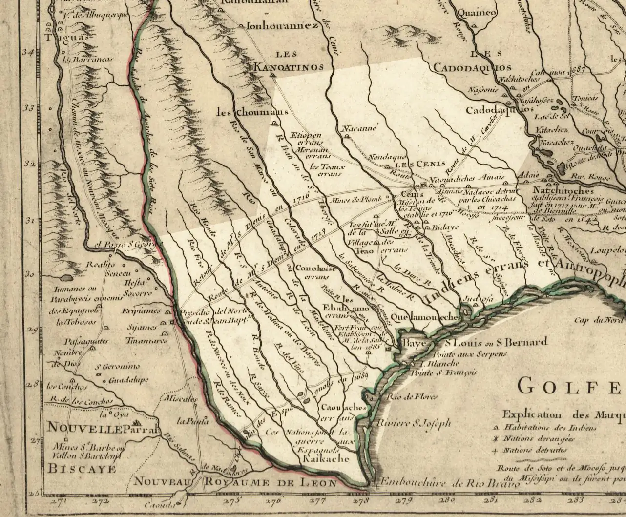
In 1718, the land we call Texas had no fixed borders, no capital, no flag. What it had was a French cartographer in Paris who decided to draw it anyway.
Guillaume de L'Isle — royal geographer to King Louis XV and one of the most respected mapmakers in Europe — published his Carte de la Louisiane et du cours du Mississipi that year. It's a sprawling, ambitious document that attempts to make sense of the interior of North America at a moment when almost nobody in Europe had actually seen most of it. And buried within it, covering a region that would eventually become the 28th state of the Union, is something that should stop you cold: a version of the word Texas. Spelled there as Teijas — marking the "Mission de los Teijas etablie en 1716" along the Trinity River, a Spanish mission established just two years prior — it sat on a page trying to hold down a place that empires were still arguing over.
Not yet a republic. Not yet a state. Just a word on a map.
What Guillaume de L'Isle Actually Got Right — and Wrong
De L'Isle wasn't guessing blind. He had access to Jesuit mission records, Spanish expedition reports, and the journals of explorers like René-Robert Cavelier, Sieur de La Salle, whose doomed 1685 expedition had planted a French fort at Matagorda Bay and thoroughly alarmed the Spanish crown into paying closer attention to the region. De L'Isle synthesized that intelligence — some of it reliable, some of it wildly distorted by distance and translation — into what was, for its time, a genuinely sophisticated rendering of the river systems and tribal territories of the interior.
The Mississippi and its major tributaries? Reasonably accurate. The Texas coast? Recognizable, if compressed. The interior? That's where things get creative. The distances between the Red River and the Rio Grande are compressed in ways that would have gotten a Spanish soldier badly lost, and some of the named tribal locations reflect information that was already outdated by the time the ink dried.
But here's what de L'Isle understood that a lot of his contemporaries didn't: this territory mattered. The 1718 map was published the same year the French established New Orleans and the Spanish founded San Antonio — both moves in a geopolitical chess match over exactly the land this map depicts. De L'Isle was working in a context where cartography was intelligence, and getting the map right had real strategic consequences.
That's worth sitting with for a second.
The Name Itself
The word Texas — or Tejas, as the Spanish had it — comes from the Caddo word táyshaʼ, meaning "friends" or "allies." Spanish missionaries and soldiers encountered the Caddo confederacy in East Texas in the late 1600s. Mistaking the Caddo greeting of alliance for the name of the territory itself, the Spaniards wrote it down. So it stuck. By the time de L'Isle was compiling his sources in Paris, the name had traveled from a Caddo salutation to a French map of a continent.
The version highlighted in the modern rendering of this image — with the approximate boundaries of the current state overlaid — makes something obvious that wasn't obvious at all in 1718: the Texas on de L'Isle's map doesn't line up cleanly with the Texas we know. The Panhandle didn't exist as a concept yet. The Rio Grande as a southern boundary was still decades of conflict and treaty-making away. What de L'Isle was marking was a cultural and political region as understood by European powers, not a jurisdiction.
1718: Everything Happening at Once
The year this map appeared is one of those moments where history piles up on itself. San Antonio de Béxar was founded in May 1718 — the same spring the map was circulating in French geographic society. New Orleans was platted in the Louisiana territory that same year. The Spanish and French were pushing hard against each other across a frontier neither fully controlled, using missions, forts, and trade relationships with Native nations as proxies.
De L'Isle's map didn't just reflect that competition. It participated in it. French maps of this period tended to draw Louisiana's boundaries as expansively as possible — conveniently swallowing territory the Spanish considered theirs. The Carte de la Louisiane is, among other things, a document in an argument.
The Spanish knew it. They produced counter-maps. The Caddo, Comanche, Wichita, and dozens of other Native nations who actually lived on this land produced no maps for European courts — but they shaped the reality on the ground in ways no cartographer in Paris could fully account for.
Why This Map Still Matters
Most people who encounter old maps treat them as decoration. Hang them in the study, admire the ornate compass roses, move on.
That's a mistake with this one.
The 1718 de L'Isle map is one of the earliest documents to apply a recognizable version of the name Texas to a defined geographic space. It shows us what European powers thought they knew about this region at the precise moment the contest for it was heating up — and the gap between what the map shows and what was actually happening on the land is itself a kind of history lesson. The confident lines and labels are a record of ambition as much as knowledge.
Modern digital renderings that overlay our familiar, straight-lined state borders directly on top of de L'Isle's original cartography make that gap instantly visible. You can see, at a single glance, what a French royal geographer imagined in a Paris study versus what three centuries of blood, dirt, and history actually produced.
They're related. But they're not the same thing.
If you've ever stood at the edge of the Caprock Escarpment in the Panhandle and looked out at that enormous flat horizon, you already know that this land has always been bigger and stranger than any map could hold. De L'Isle did his best. The place defeated him, the way it defeats every attempt to contain it on paper.
That's not a criticism. It's practically a tradition.
What's the oldest Texas map or document you've encountered — in a museum, an archive, or even a family collection? We'd love to know what's still out there in private hands that historians might not have seen.



No comments yet