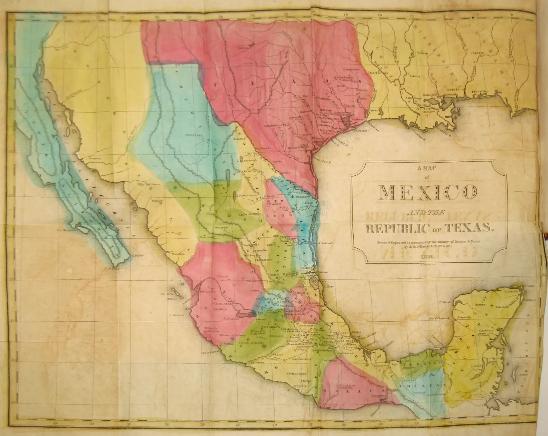
The borders drawn on a map don't just describe geography. They make an argument.
That's what makes the Map of Mexico and the Republic of Texas — compiled by Connecticut politician and writer John Milton Niles in 1838 and held today in the University of Texas at Arlington Libraries — such a striking document to sit with. This isn't just a cartographic curiosity. It's a snapshot of a world that existed for less than a decade, drawn at the exact moment when the question of what Texas was — and what it would become — remained genuinely unresolved.
John Milton Niles and the Map That Named a Republic
Niles isn't a household name in Texas history, and that's part of what makes this map interesting. He wasn't a surveyor who'd ridden these plains or a frontiersman who'd crossed the Sabine. He was a newspaper editor, a U.S. Senator from Connecticut, and a prolific writer on American geography and politics. His 1838 compilation drew on the best available sources of the period — which, in fairness to Niles, were limited and often contradictory.
The map was later reproduced in an 1844 edition, which is the version now preserved at UTA. That six-year gap matters. By 1844, Texas annexation was the burning political question in Washington. President John Tyler had submitted an annexation treaty to the Senate in April of that year — a treaty that ultimately failed, though Texas would join the Union the following year. Anyone looking at this map in 1844 was looking at it through that political lens.
And the map showed them Texas as a republic. A sovereign nation. That framing was not neutral.
What the Map Shows — and What It Gets Wrong
If you've ever examined early maps of the Republic of Texas, you'll notice something immediately: the boundaries are ambitious in a way that would be politely called optimistic. The Republic's claimed territory, as defined by the Texas Congress in December 1836, extended all the way to the Rio Grande — including land that is today part of New Mexico, Colorado, Kansas, Oklahoma, and Wyoming. Santa Fe, in the present-day state of New Mexico, was technically claimed as part of Texas under that legislation.
Mexico, of course, never recognized any of this. As far as Mexico City was concerned, Texas was a rebellious province whose "independence" had no legal standing. The Rio Grande boundary was especially contested — Mexico held that the southern border of Texas had always been the Nueces River, roughly 150 miles to the north.
What the document genuinely captures — and this is where it becomes a primary source of real value — is the geographic understanding, and misunderstanding, that educated Americans had of this enormous territory in the late 1830s. Interior Texas was largely unmapped from direct survey. The lived reality of Comanche territory, which dominated much of what Niles would have labeled as "Texas," is essentially invisible on maps like this one — which tells you something important about whose knowledge counted.
The Republic Years: Stranger Than Most People Remember
The Republic of Texas lasted from 1836 to 1846. Ten years. And most of that decade was genuinely precarious in ways that tend to get flattened out in the celebratory retelling.
The republic was broke almost immediately. President Mirabeau Lamar — who succeeded Sam Houston in 1838, the same year Niles compiled this map — ran up enormous debts financing frontier defense and an ill-fated military expedition to Santa Fe. The Santa Fe Expedition of 1841 ended in disaster, with Texian volunteers captured, marched across the desert, and imprisoned in Mexico. The Council House Fight in San Antonio in 1840 — a negotiation gone catastrophically wrong — led to a massive Comanche retaliatory raid that reached all the way to the Gulf Coast. Linnville, a port town on Lavaca Bay, was sacked and burned in August of that year.
None of that shows up on a Niles map. What shows up on a Niles map is clean lines and legible place names. That gap between the document and the reality is exactly why historians spend time with sources like this one.
Looking at It Now
Pull up the image and give it a few minutes. Look at where the settlements are clustered — along the coast, along river corridors, hugging the older Spanish colonial routes. Look at how much of the interior is essentially blank, or marked only with river names that may or may not be accurate. Look at the Rio Grande running its course down to the Gulf, staking out that contested southern boundary.
Then think about the fact that someone in Hartford or New Haven picked this map up in 1844, looked at it, and tried to form an opinion about whether the United States should absorb this enormous, complicated, violent, indebted, extraordinary place.
If you've done research using early Texas maps, whether at UTA, the Texas State Library, the Portal to Texas History, or anywhere else — what's the most surprising thing you've found in the way those documents drew (or mis-drew) the state? Drop it in the comments.

No comments yet