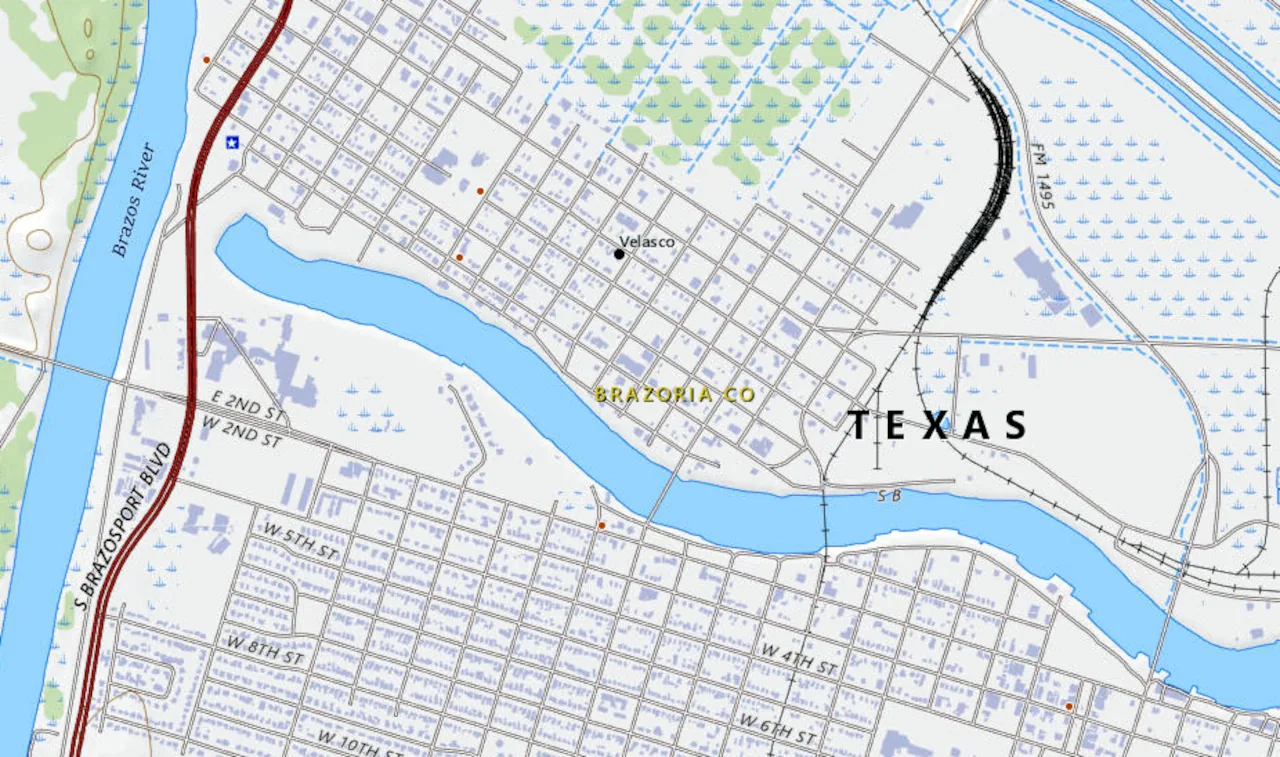
A dot on a USGS map. That's what Velasco looks like today — a geographic notation on a survey grid, sitting on the east bank of the Brazos River in southeastern Brazoria County, absorbed so completely into modern Freeport and Surfside Beach that most people driving State Highway 332 don't realize they're rolling through ground that changed the direction of Texas history. Twice.
Old Velasco — now encompassed by present-day Surfside Beach — sits on the east side of the Brazos River, sixteen miles south of Angleton, near the Gulf of Mexico in southeastern Brazoria County, and was founded in 1831. But the story starts a full decade earlier.
Before There Was a Town
The schooner Lively landed at the site in 1821 with thirty-eight men — the first of Stephen F. Austin's colonists. Nothing but a single house stood there until Mexico set up a customs port and dispatched troops in 1831 to help the customs collector. One house. That's the whole town.
The town was named for a Mexican general, as was Quintana, on the opposite side of the river. That detail gets skipped in most tellings, but it matters — Velasco was Mexican infrastructure built to manage and tax the flood of Anglo settlers coming through. Subsequently, more than 25,000 settlers entered through the port. By 1835 a customhouse, salt works, and trading posts had taken hold at the site.
Twenty-five thousand people through one river mouth. That's not a footnote. That's a door.
The First Fight
June 26, 1832. Four years before the Texas Revolution officially started, the shooting started here.
The battle of Velasco — probably the first case of bloodshed in the relations between Texas and Mexico — took place on June 26, 1832. Henry Smith and John Austin, in charge of Texans who had gone to Brazoria to secure a cannon for use against Mexican forces at Anahuac, opposed Domingo de Ugartechea, commander of the Mexican fort at Velasco, who tried to prevent passage of the vessel carrying the cannon.
The Texans numbered between 100 and 150; the number of Mexicans was variously estimated at 91 to 200. Ugartechea and his garrison were forced to surrender when their ammunition was exhausted. A conservative estimate suggests Texan casualties were seven killed and fourteen wounded — three of the fourteen later died of their wounds. The Mexicans had five killed and sixteen wounded.
According to one writer, Old Velasco became the "Boston harbor of the Texas Revolution," as the site of the battle of Velasco in 1832. That framing is apt. This wasn't a revolution yet. It was a customs quarrel that turned deadly — and once blood hit the dirt at the mouth of the Brazos, the question of whether Texas would stay Mexican was no longer academic.
The irony nobody talks about: the Battle of Velasco was unknowingly fought after the dispute at Anahuac had already been peaceably settled. The men who died at Velasco that June night didn't know the fight was already over.
Capital of a New Republic
After San Jacinto, Velasco's role shifted from battlefield to seat of government.
Following the decisive Battle of San Jacinto in 1836, Velasco was named a temporary capital of the Republic of Texas by interim President David G. Burnet. Government records were housed at Fort Velasco until the first capital of Texas was established at Columbia. Antonio López de Santa Anna signed the Treaties of Velasco on May 14, 1836.
Two treaties were signed by ad interim president David G. Burnet and Gen. Antonio López de Santa Anna at Velasco on May 14, 1836, after defeat of the Mexican forces at the battle of San Jacinto. One public, one secret. The public treaty ended hostilities. The Mexican Congress refused to recognize the independence of the Republic of Texas, as the Treaties of Velasco were signed by Santa Anna under duress as prisoner. But that's a separate argument. For one brief moment, the paperwork that created Texas was signed here — at this river mouth, in this little port town that nobody puts on the short list.
Between the Wars: Resort Season
Here's the part that surprises people. After the revolution, Velasco got comfortable.
Between the Texas Revolution and the Civil War, Velasco and Quintana served as summer resorts for wealthy plantation families of the region. Galveston businessmen Samuel May Williams and Thomas F. McKinney established warehouses and organized shipping of all kinds at the port. A seminary for young ladies — Velasco Female Academy — and a school for young men, taught by Oxford graduates, were established by 1838.
Oxford graduates. At the mouth of the Brazos. In 1838. Texas has always been weirder and more cosmopolitan than its mythology allows.
Antebellum Velasco had business houses, homes, a hotel, boardinghouses, wharves, and a customs house. Steamboats embarked from the wharves for Galveston and New Orleans. But the good times didn't last. With completion of the first intracoastal canal to Galveston Bay in 1856, the town began to decline as shipping was diverted to Galveston.
Storms, Silence, and Reinvention
In 1875, a hurricane destroyed the old town records. By 1884, Old Velasco's residents numbered only 50. Fifty people in a town that had once been the front door of Texas.
Then someone decided to try again. The new town of Velasco was surveyed and laid out four miles upriver in 1891 when a new Velasco post office was established. The port was officially opened by the United States Secretary of the Treasury William Windom on July 7, 1891.
The promoters went hard. Over $1,000,000 worth of lots were sold to Midwesterners looking for greener pastures and a seaside environment. By 1892, New Velasco had 136 business establishments and 167 residences, an electric light plant, and a planing mill. Much of Velasco, first owned by John A. and William H. Wharton, was later sold to an agent of the English Rothschild family, who planned to establish a great seaport at the site.
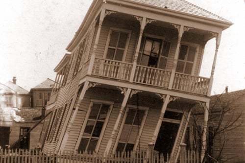
The population had reached 3,000 when the Galveston hurricane of 1900 wrecked the town.
That storm — the catastrophic tropical cyclone that became the deadliest natural disaster in the history of the United States, leaving between 6,000 and 12,000 fatalities — didn't just hit Galveston. It swept the length of the Gulf Coast. Velasco, three times rebuilt, got leveled again.
The End of the Name
Recovery came slowly, then decisively. Diversion of the Brazos River and the formation of a tidal estuary deep enough to accommodate large vessels in the old river channel subsequently revived both Velasco and nearby Freeport. Construction of chemical-industry facilities during World War II increased the population from 900 in 1940 — when the city was incorporated with E. F. Roeller as mayor — to 5,200 by 1950.
But Velasco as an independent place was running out of time. With a population estimated at 4,000 in 1956, Velasco was incorporated with Freeport on July 27, 1957. The post office became Velasco Station. The consolidation passed by a margin of just 17 votes.
Seventeen votes. The name gone by seventeen votes.
What the Map Shows
The USGS geographic depiction of Velasco — preserved in the Wikimedia Commons archive and catalogued through the United States Geological Survey's public domain work — shows the town's footprint as it was surveyed: a community pressed against the east bank of the Brazos, defined by its river orientation, its proximity to the Gulf, its whole identity built around water coming in and going out. During pioneer days, the Brazos River was the chief artery by which immigration, communication, and commerce penetrated Texas from the Gulf. Small boats regularly navigated as far as East Columbia, and customhouses were located at Brazoria and Velasco.
The map doesn't show any of that history. It shows lines and contours. Which is why you need the history alongside it — because without it, Velasco is just a place that used to exist. With it, Velasco is where Texas started bleeding, where Texas signed its independence papers, and where Texas kept trying long after most places would have quit.
The Texas Historical Commission marker at Surfside Beach still stands near the old river mouth. The marker states that here was fought a battle — the first collision in arms between Texas colonists and the Mexican military — a conflict preliminary to the Texas War for Independence.
Most people walk right past it on the way to the beach.
Do you have family connections to Velasco, Quintana, or early Brazoria County? We'd love to hear what documents or oral histories you've come across — drop them in the comments below.
No comments yet